How Wide Is Hurricane Matthew?
From talking with family and friends about hurricane Matthew currently approaching the central east coast of Florida, it is apparent that folks do not grasp this reality of the storm. They do not understand that it is wider than the state! They talk about, “it is going to hit…” but do not realize that they are in it! It is hitting and they say “it is raining and there is a little bit on wind…but it isn’t supposed to get here until….”
How Can This Be?
How can this be? Perhaps in part because of three things beyond that it is technical and most folks are not really interested in this complicated matter of tracking a hurricane or tropical storm.
- In the reporting of the storm track showing cute little dots or whirlygigs that represent the hurricane.
- The storm coordinates suggest the point where the storm is.
- The mental-perceptual connection to the satellite photos showing the vastness of the storm clouds is not understood.
Common thoughts are:
- “Well it isn’t supposed to hit this side of the state.”
- “We are just supposed to get some wind and rain.”
- “The eye isn’t coming here.”
Description of Hurricane Matthew
In her 10/06/2016 article for International Business Times
says:
More than 1.5 million Floridians were in Hurricane Matthew’s path as it potentially barreled Thursday toward the U.S. southeast coast. Evacuations were ordered in Florida, Georgia and South Carolina after the massive storm pummeled Haiti and Cuba earlier this week, killing 25 people.
The storm was expected to strike Thursday night or early Friday morning between West Palm Beach and Cape Canaveral in Florida with winds of up to 145 mph. Florida Gov. Rick Scott said the impact would be “catastrophic.” …
So just how big is the monster storm? Hurricane Matthew is more than 600 miles wide and its eye alone is 15 miles wide. In comparison, Manhattan in New York City is 13.4 miles and 2.3 miles wide, while the state of Florida is is 500 miles long and 160 miles wide at its most distant points.
Understanding the Storm
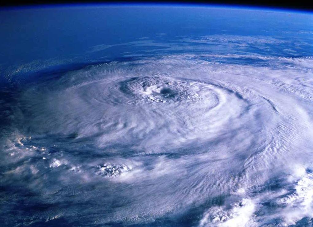
The cute little whirlygig on the weatherman’s map resembles by proportion more of a tornado. Compared to the satellite photo of the dense circulating cloud mass that truly is the storm. Even the doppler showing colored speckled areas minimizes the vastness of the storm by highlighting precipitation density areas.
But if you have family or friends in the potential path of this storm, please understand that the situation is serious. Like Cristina says just because it is predicated that the eye will pass off shore…
That doesn’t mean coastal residents shouldn’t take the storm, which threatens to bring high winds and massive amounts of rain to Florida, South Carolina and Georgia this week, any less seriously. Sandy, for example, wasn’t even a tropical storm when it hit the East Coast of the United States nearly four years ago, but it still managed to rack up millions of dollars in damages and kill 285 people.
If the eye is 15 miles wide that defines the area reported by the weatherman by the whirlygig symbol. However, in considering full width of the storm of 600 miles, there is not much of the 500 mile wide state of Florida that will not be impacted somehow. If the storm edges easterly that will move the zone of the 600 mile spread away from the west coast and central Florida areas. Things that one can face in a hurricane besides the dreaded eye, is flooding, electrical incidents from lightening, hurricane force winds, tropical storm force winds, cyclones, land slides, sinkholes, impact from flying debris, imploded doors and windows, partial or total loss of roof, power and communication outage, water contamination and numerous post storm challenges such as extended power and communication outage, food and gas shortage, mosquitoes and mold to name a few.
Preparation is Key
Tropical storms and hurricanes grow and subsided as influenced by water temperature and currents, land fall, other large weather systems or wind streams nearby for instance. People who have been through hurricanes might be inclined to say it is all or none when it comes to preparation because of the variables. During a storm is not time to try boarding up. Having emergency supplies on hand, even unanticipated things like a generator, extra gas for car, sand bags, a waterproof evacuation bag with dry clothes and sterno in case you have to flee from your damaged home are good ideas.
You can follow the storm progress and threat via the Weather Channel, your local news or radio station, a weather band radio or on the internet. Ideally know your longitude and latitude, get a tracking chart and plot the coordinates. Remember the coordinates are the center of the eye. Y0u must consider the distance that the storm covers to see if your location will be involved.
Honoring Those Effected
To those in areas suffering from the already devastating effects of this storm, regrets and prayers. If you or some one your know or love is in the storm warning areas, white light and prayers of protection from Nurses Moving Forward.
To learn more about storm preparation, tracking and helpful resources look for the related ebook coming soon compiled by a Disaster Response Nurse.